Hurricane Erin Unleashes Dangerous Waves On East Coast, Threatening Homes: Updates
Hurricane Erin was unleashing powerful waves and rip currents along the East Coast, threatening beachfront homes and flooding roads as authorities urged people to stay out of the water.
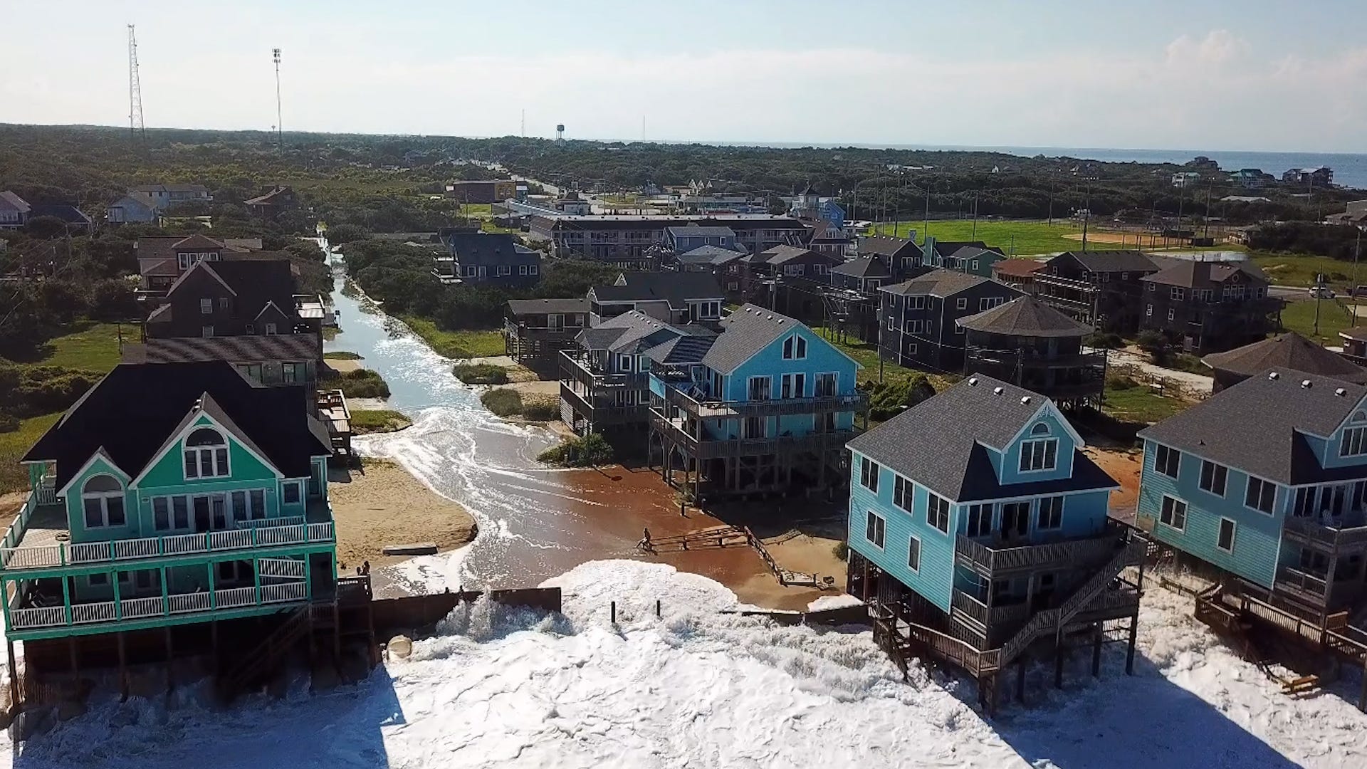
The National Hurricane Center has warned that roads in the low-lying barrier islands will become impassable, with powerful waves of 15 to 20 feet crashing ashore. By the evening of Aug. 20, the North Carolina Department of Transportation closed a portion of Highway 12, a crucial artery in the Outer Banks, due to flooding.
Major flooding was forecast at more than a half-dozen tidally influenced locations along the mid-Atlantic coast, including at Duck, North Carolina; around the entrance to the Chesapeake Bay; and at Lewes, Delaware, as the storm surge from Erin flowed into communities. The National Weather Service said flooding at some of these locations would pose a "significant threat" to property and life, necessitating evacuations.
Tropical storm and storm-surge warnings were in place along the North Carolina coastline. Coastal flooding was expected to peak during high tide on Aug. 21.
In New Jersey, swimming and other water activities were prohibited on beaches, with high surf and rip current warnings in effect through Aug. 22, the weather service said.
Developments:
∎ Erin was a Category 2 hurricane as of the early morning of Aug. 21, with maximum sustained winds of 105 mph and higher gusts. It was located about 205 miles east-southeast of Cape Hatteras, North Carolina and was moving north-northeast at 17 mph.
∎ The National Hurricane Center said it is monitoring two other areas for tropical development in the Atlantic. "One has a 70% and the other 40% chance in the next 7 days," according to the hurricane center.
∎ Earlier in the week, the coastal counties of Dare and Hyde – located in North Carolina's Outer Banks region – ordered residents and tourists to evacuate the vulnerable Ocracoke and Hatteras islands, which see swelling populations during the summer months.
∎ Erin has made its closest approach to the North Carolina coast and will move further off shore, hurricane forecasters said the morning of Aug. 21. Erin's timeline for passing by the U.S. East Coast has accelerated some, and it is expected to slowly weaken until it reaches post-tropical cyclone status.
Coastal flooding from Hurricane Erin is expected across much of New York City’s waterfront, possibly impacting homes, streets and businesses from Aug. 21 to Aug. 22, city officials warned.
Advisories were in place across the five boroughs, with flooding of as much as 2 1/2 feet expected on the evening of Aug. 21 in parts of southern Queens with high tide, the city Emergency Management said on X. In Queens, officials expect widespread flooding of low-lying properties, roads and basements near waterfronts. Flooding would continue with Friday’s high tides.
Manhattan, Brooklyn, the Bronx and Staten Island are projected to see 1 to 2 feet of inundation beginning the evening of Aug. 21 and into Aug. 22, city alerts warned.
Officials advised people near coastal areas to move cars to higher ground before high tide, and to protect basements, which are often converted into apartments that can be threatened by flooding.
− Eduardo Cuevas, USA TODAY
The weather service and state officials have provided the following information:
New York: Widespread dune erosion and beach flooding are likely with successive high tides through the morning of Aug. 22, with waves of up to 15 feet or more and higher-than-normal tides. Gusts up to 40 mph are possible, with the highest winds expected along eastern Long Island.
State officials advised residents to prepare for the possibility of dangerous conditions along beaches and coastal communities. New York Mayor Eric Adams directed the closing of all beaches for swimming on Aug. 20 and Aug. 21.
New Jersey/Delaware: Tropical storm-force gusts are possible along the coast on Aug. 21, with breaking waves of 7 to 11 feet.
Maryland: Higher tides could lead to coastal flooding. Coastal flood advisories were issued, including a flood warning for Annapolis, where flooding is expected in the low-lying historic community.
Virginia: Minor or isolated coastal flooding is expected through the weekend.
This forecast track shows the most likely path of the center of the storm. It does not illustrate the full width of the storm or its impacts, and the center of the storm is likely to travel outside the cone up to 33% of the time.
Contributing: Reuters
Popular Products
-
 Self-Inflating Foldable Sleeping Mat
$161.99$89.99 -
 USB Rechargeable Hand Warmer Pocket H...
$25.99$17.78 -
 Waterproof Under Seat Rear Cycling Pouch
$33.99$22.78 -
 Waterproof Bicycle Bag Pouch
$18.99$12.78 -
 Portable USB Rechargeable Clip Cooler
$65.99$45.78