Travel Journal: Driving The Alaska Highway In 2006
There’s nothing quite like a cross-country (or cross-continent) road trip. The month of May 2026 marks 20 years since my dad and I drove from Arizona to Alaska and back. I was 24 years old at the time. In honor of the two-decade trip-versary, I decided to share my personal account, pulled from a Microsoft Word document where it had been logged all those years ago.
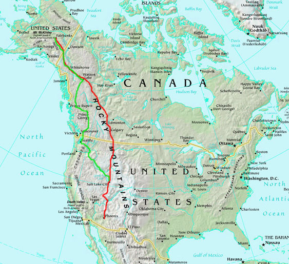
To sum it up: The Alaska Highway was one of the most engaging and cinematic drives I’ve ever experienced. The roughly 8,000-mile round-trip journey took 11 days from Phoenix. And yes, I got an oil change at the halfway point in Fairbanks. Planning for the drive, incidentally, was in the works for months leading up to it. I connected with a resource called The Milepost that publishes an annual hard-printed (and very comprehensive) travel guide for the Alaska Highway. I studied it from cover to cover.
Here’s your play-by-play, along with just a few photos I carved out from the roughly 300 I took. It’s a lengthy read, so go get your coffee or a Red Bull first if you want to follow along.
Saturday, May 6, 2006
We picked up dad’s bags at the hotel in Eden and headed down the canyon. It was a very nice day up there. We ate at Maddox – the turkey steak was awesome. Then on to I-15. Malad area (ID) was really rainy, but other than that we’ve stayed pretty dry. We stopped in Idaho Falls and then Dell, Montana, where we talked to a nice older couple from Alberta. They gave us some tips on getting around Edmonton and told us to go see the huge mall. We stopped in Butte for a fill-up (gas keeps getting cheaper as we go north) and then finally came up to Great Falls. We passed through some really beautiful canyons with the Missouri River…. Awesome cabins. Dad wanted one. His eagle eyes were busy at work trying to spot animals. We didn’t see many. We passed through a tiny town called Craig and got a pic. So far, so good on the voyage! The car is holding up 100%, with 219,200 miles as of tonight. We walked over to the buffet at the Flying J next door for some soup. The sunset was really cool.
Sunday, May 7, 2006
We are now in Whitecourt, Alberta, Canada! What a day on the road. It was almost exactly 10 hours on the road. I got really excited when we pulled into town and I saw the first sign announcing we were headed in the right direction — we are staying at the Ramada right across from the “Alaska Highway Motel.” Whitecourt is a bigger town than I thought it would be. Plenty of wildlife. We are fascinated with the accuracy the Milepost book has on its road trip descriptions — every mile is described in detail. Dad was glued to that and my Rand McNally atlas the entire trip, and we were constantly trying to figure out how much further we’d have until our next destinations. A few things are really throwing us off (or making things difficult). The speed limits are in km/h and they’re low, too. Most towns, you have to slow down to like 50, which is really only about 35 mph. It is weird to drive along and see the speed limit sign, “Maximum 110.” The gas is sold in liters, and the Canadian currency thing is altogether crazy. We have had scattered clouds and bursts of rain for a large portion of the day, but plenty of sunshine. Everything seemed to get greener the farther north we got.
The initial drive from Great Falls to the Sweet Grass border crossing was easy. The customs agent only asked a few questions and then let us pass on through. Alberta is very “farmy” — mile after mile after mile of huge farms. We noticed that everyone takes really good care of their barn. We made a pit stop at a town called Stirling, Alberta, which, according to the Milepost, is the oldest and best-preserved Mormon settlement in the entire country of Canada. It’s a tiny little town, and there was an interpretive center that had all kinds of information on the history and settlement. First stop in Canada for gas was Fort Macleod. On the way there, we passed through Lethbridge, which was a really confusing mix of windy roads through town. We did figure out where we were going. Fort Macleod didn’t have much to offer, but we used a CIDM ATM machine and got some Canadian cash.
Next big city was Calgary — it was a lot bigger than I’d expected. We saw lots of Alberta plates, of course, as well as some from British Columbia, Saskatchewan, Ontario, and Manitoba. No other Utah. Heard some radio ads announcing the weather at 3 and 17 degrees — Celsius that is! Haha. That will take some getting used to as well. At Red Deer, we gassed up at Gasoline Alley and took off across Highway 11 westbound. That road was just two lanes wide, but very nice and no traffic. The road cut through the trees and the scenery was pretty much the same for a LONG time. We went through Rocky Mountain Home and then hooked up with the 22 north, then up to the 43 in Mayerthorpe. Dad was doing a great job navigating, and I haven’t had him drive yet. Canada has all the same stores as the U.S. — Walmarts, etc. Pretty wide-open spaces. I’m sure dad wishes he could have seen a few more mountains.
Our phones are on analog roam, so I’m sure any calls we take/make are costing us a fortune. Today was our longest-mileage day of the trip: just over 600 miles. I think we have gone through the 1,000 songs on my iPod already. Canadian radio doesn’t have much to offer. We passed a town called Bentley in the middle of Alberta, but didn’t get a picture in time as we flew past. 9 p.m. and still light outside. We went to Subway for dinner and then cruised into downtown Whitecourt. It was a beautiful evening — rainy, but very green and cool, and it smells nice!
Monday, May 8, 2006
It has been the most adventurous day of the trip yet! We are staying at the Northern Rockies Lodge in Muncho Lake, British Columbia. We are in the Frog River room, #201, on the main level of the lodge. We just finished our Hunters Schnitzel pork feast in the dining room and were served by our Swiss waitress Luzia who is here working for the summer. Dad is in heaven with these surroundings! The lodge is the largest log building on the Alaska Highway, with 45 rooms and offering bush plane tours throughout the summer. The season is just getting started this week. There are cool little individual cabins out back, but our room is really nice too. There are very few people staying here tonight.
It was a very long day, mileage-wise and time-wise. We put in well over 700 miles and about 12 hours, but that is deceiving because it’s still light outside, and it’s getting late. The view out our back window of the peaks and lake is incredible. The lake still appears to be frozen over. Dad saw his share of animals today — I almost hit a huge caribou head-on, and just about plowed through a herd of about 10 stone sheep in Stone Mountain Provincial Park. We also saw some moose, antelope, everything. The morning started out in Whitecourt with mixed rain and snow. It systematically got worse but luckily was never sticking to the road. The scenery was much the same as yesterday. There were fewer and fewer cars on the road and it ended up being just us and the huge trucks, all equipped with huge guards on their front bumpers probably to annihilate any animal who dared get in their way. I got a check-engine light once, but it reset when I turned the car off; still, it was scary. I’m sure it’s just that recurring EGR problem again.
The rain and snow continued as we got into Grande Prairie, where we started seeing signs promoting Alaska as a destination. That was exciting! We got a picture at Little Smoky before GP (population 34) and Beaverlodge after GP (with the huge beaver statue). Finally, we rolled into Dawson Creek! The “arrow” sign announcing the start of the Alaska Highway was easy to find. It was snowing hard in town, and we didn’t feel like walking around in that kind of weather, so we got a couple of pictures and moseyed onward. Weather got a little bit better after that as we drove toward Fort Nelson. We stopped for lunch at A&W in Fort St. John and it was a nice day there. That town is pretty big. Gassed up at Safeway. We grabbed a picture at Pink Mountain and blasted past the Sasquatch Crossing Lodge (where they apparently have sightings of Sasquatch daily). We ran into a little construction on a very long descent. We had to wait about 15 minutes to be escorted through the construction zone. Got full-service gas service at Fort Nelson, and we decided to go farther today even though that was our initial destination. It was still very light outside.
The highway after Fort Nelson quickly became void of center or outside lines, and it was more gravelly than smooth. Still not too bad for dust. Occasionally, I had to dodge pot holes the size of manhole covers that were deep! I managed to get around them all. There are also spots of gravel that only last a few seconds but always catch you by surprise. Other parts of the highway are damaged by frost heaves and are marked by signs with a bumpy road picture. Cell phones became worthless, even on roam. We gained a LOT of elevation on 10-percent grades around Steamboat. When we stopped to get a pic, the car smelled hot, but the gauge never moved. We entered Stone Mountain Provincial Park and we saw some of the most beautiful scenery I have ever witnessed. The road was winding around rivers, lakes, and huge stone mountains (thus the name) that were snow-capped and massive-looking. Dad was on the prowl for animals and we saw tons. The lodge at Toad River was closed for the season, so we decided to keep going once more and ended up at Muncho Lake, historic mile 456. It is an awesome setting. It’s so quiet outside. Dad made a friend with an Alaskan Husky dog on the property.
Tuesday, May 9, 2006
Weather was really nice all day today! I was glad. We did run into a little bit of construction (about five miles of gravel and potholes), some intense frost heaves (just about launched the car), and an area where we didn’t see another vehicle for about 50 miles. Most of the highway can be driven at 75 mph, thankfully. Tomorrow, we’ll be in Fairbanks. Now we’re in Haines Junction, Yukon Territory, at the Alcan Motor Inn. This town (population 811) is tiny. We walked over to the general store next door and checked it out. Our neighbors in the room next door are from North Dakota.
We started off the day at Muncho Lake, but went just a few miles down the road to Toad River Lodge and got some hot breakfast there. It was a log cabin-style establishment and they had some monster animals in there. Dad saw a few more animals (live) to take pics of along the road. We went to Watson Lake and checked out the signpost forest — it’s huge. We gassed up at an old-fashioned-looking store (the only choices were diesel and unleaded). Quality gas, I’m sure.
Next stop was Teslin, where we took a tour through a cool wildlife exhibit and drove across the longest bridge on the Alcan. A couple of hours down the road, we were in Whitehorse and found our way to Main Street for some fuel. Then we ate at Boston Pizza; the portions were HUGE and the food was great. Finally, we made the last stretch to Haines Junction and here we are at the Alcan Motor Inn. Dad talked to mom in Whitehorse, but other than that, we have had zero cell service and no access to the Internet. We went to gas up at Fas Gas and then ate sundaes at the Frosty Freeze. Not many other people in town!
Wednesday, May 10, 2006
This morning, we were on the road once again at 7:30 a.m. sharp. We paralleled some beautiful mountain peaks for several miles and went over some bridges at Kluane National Park. Had some sheep sightings on Sheep Mountain (dad tried to zoom in, but they were too far away). The road got really bumpy with frost heaves — it was like driving down a roller coaster. We would blow past the trucks and trailers. A few sections of road were under construction, but the gravel was decently graded, and we got through it quickly. The road maintenance people are really good about putting up cones and orange flags on areas of the road where drivers needed to exercise caution. Most of the time, it’s because of those huge bumps or missing/loose pavement.
In a couple of hours, we were in Beaver Creek and enjoyed a delicious homemade breakfast at the 1201 Motor Lodge. Dad was loving the interior of that place — taxidermy animals galore. I bought a couple of bumper stickers. Just 20 miles down the road, we came up on the Alaska border! I got a few shots at the much-awaited photo op, and we talked with a couple from Minnesota who were doing the highway for their first time as well. Getting into the Alaska border was a piece of cake. The speed limits went to 55 mph instead of 100 km/h, and the road was noticeably in better condition.
Next stop within the state was Tok, but we didn’t stick around too long. Scenery was more of the same, but it was beautiful. We soon made it to Delta Junction at mile 1,400-something — the official end of the Alaska Highway. We stopped by the visitor’s center and got some pictures at the last milepost marker. It was a beautiful blue-sky day outside and we had great weather all day today.
The last leg of our journey was to Fairbanks, another 90 miles or so from Delta Junction. En route, we just had to make a pit stop at the North Pole to visit Santa’s house! That place is for real! The address is St. Nicholas Drive, and they have Christmas stuff for sale inside. We bought five square inches of North Pole land for $7.00 each to send to mom and the two grandmas for Mother’s Day.
Ten more miles away: Fairbanks! We made it. We found the Honda dealer, “Auto Service Company,” and scheduled an appointment for my oil change, then checked into the Captain Bartlett Inn for the $55 Alaska Special. It’s a pretty run-down facility, but at least it has Internet. Went and got our Mother’s Day gifts Fed-Exed, and then went back to Honda. Finally, we stopped at the Roundup Steakhouse for a nice Fairbanks meal. Every car here has a plug sticking out of the engine compartment for block heaters.
Thursday, May 11, 2006
I am typing this entry from inside the car. We’re having a marathon of a day with our driving — dad has been at the wheel the whole time. We are just about to Teslin (we passed Whitehorse about 94 miles ago) and our destination this evening is Beaver Post, near Watson Lake, Yukon Territory. Weather has been variable; we’ve seen snow early in the morning near Tok, then clear skies, then some really dark clouds and cloud bursts just past the border. We stopped in Tok for a very filling (heavy) breakfast at Fast Eddy’s and we ran into a couple from Salt Lake City who were on their way to Anchorage.
After breakfast, we gassed up at the Chevron (probably the last good-quality gas we’d see for a few days) and headed toward the Canadian border. Again, crossing through was a breeze. In no time, we were blasting through the whoop-de-doos on the highway again en route to Haines Junction, but they didn’t seem to last nearly as long as when we drove those bumpy roads the first time. Dad spotted a grizzly bear just before we hit a construction zone and he said that it “made his day.” We got some gas at Fas Gas in Haines Junction, and I got out of the car to run around a little while — I was getting antsy after so many hours in the car. Another 1.5 hours down the road, we cruised through Whitehorse. My car turned 222,222.2 miles and we pulled in for gas at Shell. A lady there asked us to jump-start her car, so she borrowed some jumper cables and we helped her out.
Going back down the highway (again no cell service), we came across a white Chevy Cavalier that was across the guardrail on the right-hand side of the road, with two people standing on the side of the road. We stopped to see what was going on, and the guy said they were okay, just waiting for a tow truck. I have no idea how they were able to get their car on the other side of that guard rail without rolling it into the huge ravine just inches away. Now 10:49 p.m. and still light outside (we are still north of the 60th parallel). We are in a cabin at the Beaver Post in Watson Lake, Yukon Territory. They are cool little cabins, with a huge jetted tub in them. Haha. Really roughing it, aren’t we?
It was an 800-plus-mile day for dad today, and we’re tired of being on the road. We hit a bird, and dad watched it fly over the car and then onto the road in the rearview mirror. Ha!
Friday, May 12, 2006
We got a bit of a late start this morning from the Beaver Post cabin; it was about 9:30 when we had finally gotten ready to head out for the day. Dad had parked the car with the wheels turned all the way, and as I was loading up my bag, I noticed that the driver’s side front tire was completely worn through the tread on the inside. The tire was near-new when I installed it in St. George! Something is really messed up with the alignment. It would have been much too risky to travel far on that tire with it as worn as it was, so we went to the Junction 37 gas station and changed the tires around in the mud and rain. We were on an unfamiliar road 150 miles away from our destination and wanted to make sure we got there.
After filling up, we hit Highway 37 and headed directly south, finally leaving the Yukon Territory for the last time. Highway 37 was one of the most scenic drives of the whole trip. It was a two-lane, curvy, mountainous road that wound us through the Cassiar Range. About 25 miles of the 450-mile road ended up being gravel, but at least it was smooth and we didn’t deal with too much traffic — hardly any, actually. There weren’t any center-line markings on the road and there were a lot of areas in need of repair much like the Alaska Highway. I was at the wheel and dad was on the hunt for animals again. Today was a bear day and nothing else. In all, we (he, actually) saw EIGHT bears! He would all of a sudden scream “Stop!” and I’d slam on the brakes and throw the car into reverse so we could go back for a picture. We even saw a baby bear cub with its mother that let us get a few pictures at Meziadin Junction!
We spent most of the drive high in the mountaintops, surrounded by a lot of snow. Most rivers and lakes were still frozen solid at the higher elevations, but once we started descending, we came across some spectacular waterfalls that were right along the highway! The mountains were incredible, and you could see where avalanches had happened over the winter. We managed to kill a couple of birds who flew directly toward the car, but we didn’t have any other run-ins with wildlife on the roadway. We did indeed reach our first destination of Dease Lake, a tiny town of (from what we saw) Indian people who lead a very simple life. I had a clubhouse sandwich and a bowl of soup, and we met Momma Z, the owner of Momma Z’s Café. She was really nice! There were three hitchhikers across the street trying to get to Whitehorse. We had a feeling they’d be standing there awhile.
We headed southbound once again and our only stops on the 37 were for periodic bear sightings. We only had to slow down a little bit for the dirt sections of road (which had been much improved since the Milepost section on that highway was written). We gassed up at Kitwanga at the junction with Highway 16 east and then took that route all the way to Prince George, which is where we’re staying tonight. The 16 was another very scenic drive; it took us through some very small but very clean towns. The speed limits in Canada drive me nuts. Most of the road was 100 km/h (about 60 mph), but in all the towns, you have to slow clear down to 30 for several miles. The highways around here always take you straight through the center of town. As we rolled into Prince George tonight, we could see the full moon; it’s the first night we’ve traveled after sunset. But sunset was at about 11 p.m.!
Saturday, May 13, 2006
We are in Sunnyside, Washington, after having gone to about 3-4 other hotels in Yakima without having any luck finding a room. There is some kind of conference in town and everybody is sold out. We almost thought we’d have to continue on to Oregon or Idaho to find a place with vacancy! Today was another long day on the road. We started at the Ramada in Prince George, British Columbia, and headed south on Highway 97, which wound around the B.C. countryside and green hills and farmlands. The area is so moist that there are lakes and rivers everywhere; nearly every community was formed around some type of lake.
Again, the drive was slow going because of speed limitations (traffic was never an issue), but we had perfect, blue-sky weather all day long. We stopped briefly at a place called Caribou Castle, where they had an “actual-size” skeleton of Sasquatch. I had to have a picture of that. Several hours into the drive, we reached our first destination of Cache Creek, where we got onto Highway 1 heading south. That road took us through some spectacular mountain ravines, where we snaked along the cliffsides with the Thompson and Fraser rivers down below. The grades were steep, but the scenery was amazing — some incredible all-around views of the steep, rocky mountains, with green everywhere. We drove through a series of six tunnels en route down the canyon.
Eventually, the road opened up to two lanes wide and in no time at all, we were at the Canadian border at Sumas. The checkpoint went quickly, and the customs officer said we were crazy for having driven to Alaska and back in eight days. It’s crazy to think that we were in Fairbanks just two days ago. We’ve covered some serious ground. Finally in the United States once more, our phones began to work and we got bombarded with voicemails and text messages.
We found our way to Interstate 5, which took us through traffic jams (the worst we’d seen all week) and eventually onto the 90 Eastbound toward Snoqualmie Pass and over to Ellensburg and the eastern part of Washington. Finally, we tracked down a hotel room, and now we’re going to relax for a few hours before making the last leg of our journey into Salt Lake City tomorrow.
Sunday, May 14, 2006
We’re in Salt Lake! Had an easy drive the rest of the way home. We were actually gone by about 7:15 a.m. from Sunnyside, and headed out on the 82. We gassed up in Baker City, Oregon, and then again in Twin Falls, Idaho, where we also stopped at Chili’s for lunch. From there, it was just a short 230 miles to the house here in SLC. Dad and I switched up driving with each gas stop and we were here by about 5:30 p.m. What a drive that whole trip was! Dad and I were talking about the fact that we could have driven from San Francisco to Boston and back (and then some) for as many miles as we drove! Wow.
Here’s a one-minute video with a few scenes from the drive (gotta love the vintage quality from my old Canon PowerShot four-megapixel digital camera).
I would say that this was the trip of a lifetime, but I went back again 10 years ago in 2016. And that time, I went four hours beyond Fairbanks to the entrance of the Arctic Circle on the Dalton Highway.
I should be making the trip again this year (to keep up my 10-year cadence and all), but there’s just too much going on. Maybe 2027 will be my year. Who’s game to join?
And by the way, I do still own my one square inch of North Pole property.
Popular Products
No popular products available in this category.